Yet another weekend featuring impactful storms is on the agenda for locations across the Gulf coast and Southeast, AccuWeather meteorologists warn.
Through the remainder of the weekend and into the start of the workweek, the risk for severe hazards ranging from flash flooding, tornadoes, hail and damaging wind gusts will persist across a region that has recently been inundated by flooding downpours and robust storms.
“Ample and persistent moisture from the Gulf will provide one of the necessary ingredients for severe weather. As moisture combines with a dynamic system in the upper levels of the atmosphere, it will provide the necessary lift and shear to produce an environment conducive for damaging wind gusts, hail and tornadoes, some of which can be strong Saturday afternoon and evening,” explained AccuWeather Meteorologist Grady Gilman.
AccuWeather.com
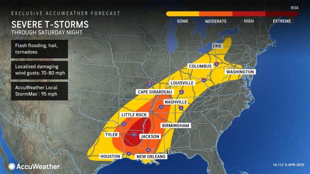
“The greatest threat for severe storms, including the risk for numerous and even destructive tornadoes, will lie across north central Louisiana into southeastern Arkansas and western Mississippi during the afternoon and evening on Saturday. This includes portions of I-20, I-49 and I-55 and cities like Alexandria, Louisiana, and Jackson, Mississippi,” noted Gilman.
Saturday night, some tornadoes can even develop under the cover of darkness across the Mississippi Valley, which poses an even more dangerous situation for those not awake and aware of the risk.
Have the app? Unlock AccuWeather Alerts™ with Premium+
Gilman added that tornadoes can also occur farther north across the mid-Mississippi and Ohio River Valleys, including in areas that are experiencing significant, life-threatening flash flooding.
Since midweek, numerous locations across western Kentucky have already recorded upwards of 10 inches of rain as of Saturday morning, submerging cars and leaving roadways impassable.
Threat continues on Sunday in the Southeast
AccuWeather.com
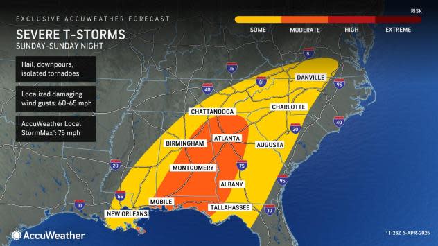
“Although not as conducive as Saturday’s environment, there will still be plenty of juice left in the atmosphere to pose a moderate risk for severe weather on Sunday across the Southeast, including the major Atlanta metro. Flooding downpours, damaging winds and hail will be the primary threats, but tornadoes will once again be possible,” warned Gilman.
Localized damaging wind gusts between Sunday and Sunday night are expected to range upwards of 60 mph within storms, and can even approach the AccuWeather Local StormMax™ of 75 mph in the most robust thunderstorms.
Higher population centers from Mobile, Alabama, and Tallahassee, Florida, on northward to Montgomery, Alabama, Birmingham, Alabama, to Atlanta, will all face the risk of being impacted by drenching thunderstorms as the day goes on.
As the main line of storms advance eastward across the Southeast on Sunday, there can even be rain and thunderstorms with severe characteristics that reach as far north as Virginia, forecasters warn. Rain and showers are still expected to extend into surrounding areas of West Virginia, southern Pennsylvania and areas of the mid-Atlantic region, with thunder likely into southeast Pennsylvania and central New Jersey.
Additional thunderstorms along the Southeast coast Monday
AccuWeather.com
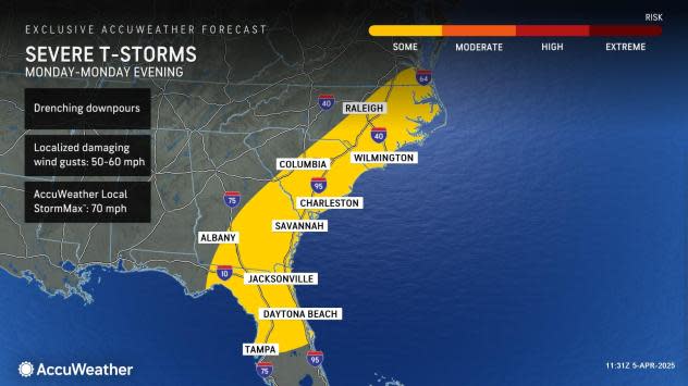
While thunderstorms that continue to push eastward on Monday to the coast of the Carolinas and through northern Florida can still be disruptive, they are not projected to rise to the same magnitude of storms over the weekend.
“The system loses steam into Monday but will still be present as the front moves eastwards, threats will mainly be in the form of heavy downpours and isolated damaging wind gusts. The threat for storms will be confined to the Southeast coast into Florida’s northern peninsula,” highlighted Gilman.
Beyond Monday, forecasters say that much of the Central U.S. and East will finally catch a break in terms of rounds of severe weather and flooding. While a brief stretch of calmer weather is much needed, the recovery time from storm cleanup and high river levels across the Mississippi, Tennessee and Ohio valleys can extend on the order of weeks rather than days.
Want next-level safety, ad-free? Unlock advanced, hyperlocal severe weather alerts when you subscribe to Premium+ on the AccuWeather app. AccuWeather Alerts™ are prompted by our expert meteorologists who monitor and analyze dangerous weather risks 24/7 to keep you and your family safer.